DigiCity
Универсальное ПО DIGICITY, созданное для управления сервисами и системами мониторинга умного города
BUDGET SAVINGS
Saving electricity
USE DIGICITY
Large user reach
COMPLETED PROJECTS
Many satisfied customers
PARTNERS
Working with famous brands
Modules of DigiCIty.AI
We present the main modules that make up the system.
Smart Lighting
Программная платформа, обеспечивающая управление уличным освещением, а также позволяет реализовать целый комплекс сервисов в области smart city.
Control cabinets
A virtual or digital representation of a real or potential object. Created for buildings, industries, and agricultural enterprises.
Meteorological analytics
Motion recognition system to ensure pedestrian safety at night or in bad weather at uncontrolled crossings
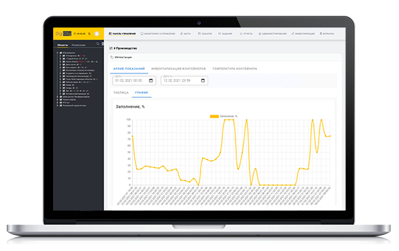
Smart trash bins
The universal fill sensor allows you to monitor the fillability of various containers.
Smart lighting module
- Detailed information about each lamp or power line.
- Tracking the readings of meters and devices.
- Quick access to instructions and equipment data sheets.
Advantages of implementations
List of all technology services used to create and operate the DigiCity application:
BUDGET SAVINGS
Saving electricity
BUDGET SAVINGS
Saving electricity
BUDGET SAVINGS
Saving electricity
Отображение следующих объектов на карте ПО DigiCity
Lighting networks
- Detailed information on each support, control cabinet, lamp or power line
- Quick access to instructions and equipment data sheets.
- Monitoring warranty and maintenance periods.
Water supply
- Displaying the sewerage and water supply system on the map (external and underground lines)
- Distribution of the city on the map by operational areas
- Design mode - creating a circuit at the design stage
- Displaying repair work on the map
Heating networks
- Displaying all heating networks on the system map
- Design mode - creating a circuit at the design stage
- Possibility of quick attachment of documentation to the object card
- Quick access to technical characteristics of each pipeline section: diameter, length, material
Forest belts
- Displaying the forest belt system on the map
- Design mode - creating a circuit at the design stage
- Possibility of quick attachment of documentation to the object card
- Quick access to the characteristics of each site
Reservoirs
- Displaying on a map the system of all water bodies of a given territory
- Display information about the owner or tenant of the site
- Design mode - creating a circuit at the design stage
- Display of the area of a water body, hydraulic connection, objects in a water body
Agricultural fields
- Displaying on a map the system of all agricultural fields of a given territory
- Display information about the owner or tenant of the site
- Possibility of quick attachment of documentation to the object card
- Displaying the area of the cultivated field
Description of the technology stack
List of all technology services used to create and operate the DigiCity application:
Programming languages:
— HTML, PHP, CSS, JavaScript, Go.
Frameworks:
— Vue.js, Сodeigniter.
DB, DBMS:
— PostgreSQL, Redis.
Version control systems:
— Git, Gitlab.
Server and cloud infrastructure:
— Docker, Docker Compose, Nginx, PHP-FPM.
Оставьте вашу заявку
The software cost is determined on request,depending
on the requested characteristics.
To receive a commercial offer, please send us an email: office@digicity.io
Download documentation: